

Projects
Command Area Monitoring - In House
Irrigation and Command Area Development (I&CAD) Department is the member of Water Management Committee an Apex body constituted by Government of Telangana at state level. Water related issues like regulation, performance, convergence and Information on crop type, extent under major and medium irrigation projects of Telangana State are the requisites of the committee. The committee evinced keen interest to know the scope of "Satellite Remote Sensing based monitoring of major and medium irrigation projects" of Telangana State. TRAC is being the nodal agency for carrying out remote sensing and GIS based studies in the Telangana state. As per the recommendations of the committee, Telangana State Remote Sensing Applications Centre (TRAC) is continuously monitoring the command areas of the state over last few years.
ObjectiveThe prime objective is to evaluate the cropping pattern in the command areas using satellite remote sensing techniques supplemented with field data during Kharif & Rabi seasons for every year. Methodology The command area boundaries of each project have been delineated based on available maps gathered from the field offices of the respective projects. Wherever the maps are not available the command boundaries are demarcated based on cropping pattern and terrain characteristics, interpreted with the help of satellite data and drainage pattern of the area. Remote Sensing & GIS tools have been employed for the cropping pattern analysis. AWiFS/ LISS-III/ Landsat-8 Satellite images are classified to identify for each command the spatial extent of Wet and Irrigated Dry (ID) crops. Multi date interpretation is performed on available satellite data, so as to avoid cloud cover and analyse the best reflectance available in either of the images. The Interpretation is validated using the Ground Truth data. The performance indicators viz. cropping pattern, irrigated area for all the projects at project level is estimated.
Results of Kharif 2015-16:Year wise Comparitive analysis of Kharif Crop in Major projects Year wise Comparitive analysis of Kharif Crop in all Medium Projects
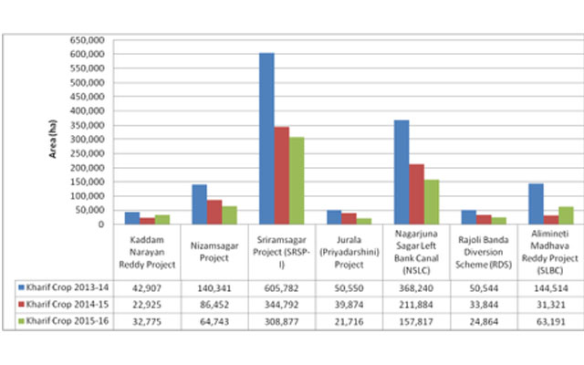

- The Kharif crop area, in all the major and medium irrigation projects, for the current year, 2015-16 is 9% less when compared with the previous year 2014-15.
- The performance of Major and Medium irrigation projects of Godavari basin is comparatively better than that of projects of Krishna basin.
- The performance of command area of both major and medium irrigation projects put together was moderate.
- The major irrigation projects performed moderate when compared to medium irrigation projects.