
Geomatics
Chief Commissioner Land Administration has awarded the Spill over works of Bhu Bharati Project pertaining to Nizamabad District . Under this project TRAC has to carryout Identification of Encroached Land Parcels and carryout Spatial, and Textual/Attribute data corrections, and generate Geo-rectified Village map.
- Spatial Correction:
- Splitting of land parcels LP and projecting them as individual (Land Parcel Map Layouts) .
- Polygons of land parcels to be converted into line feature so as to generate vertexes along the polygons for measurement of inter vertex distances.
- Vertex's to be converted to point feature so as to generate coordinates for each vertex.
- Bi-junction and Tri Junctions of the adjoining land parcels to be denoted as Alpha and Numeric's.
- Each LPM is to be provided in Poly, Line and Point features.
- Demarcation of Encroached Land parcels:
- Land Parcels subjected to encroachments are demarcated and segregated with unique symbology
- In accordance with the details provided in format ix of the land registration records corrections will be carried out both in LPM and LR simultaneously.
- Encroached LPM's are assigned new survey number and entries made into the remarks column of the LR Record.
- Textual / Attribute Data corrections: Textual / attribute information of the land registration records, LR'S will be verified with respect to corresponding LPM and final LR is prepared. Inputs: Source Data by O/o CCLA. Scales: The scale and orientation of the sketch can be altered depending upon the size of the field. The scale shall vary 1:1000 for LPM upto 2 Ha Area, and 1:2000 for upto 2 Ha area to 8 Ha area and 1:5000 for over 8 Ha area. Outputs: Final LPM to be provided on A4 size, Land Registers LRs on A3 Size and Final Village Map on A0 Size. JPEG : Input Three JPEGS of LPM, LR and Village Map Output Three JPEGS of LPM, LR and Village Map
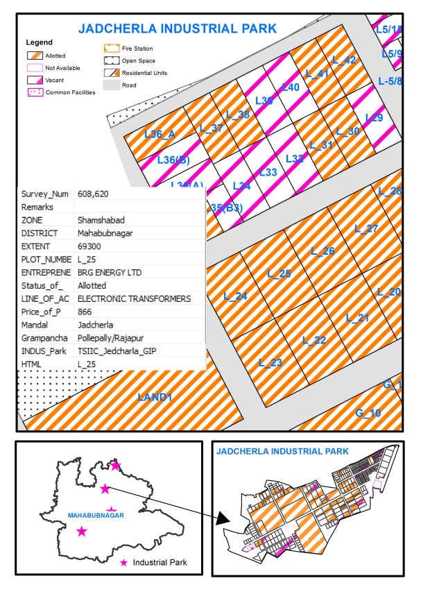
Sponsored by Telangana State Industrial Infrastructure Corporation, Government of Telangana.
Ease of doing business in Telangana State is one of the flagship programs of Govt. of Telangana. TRAC is providing a GIS web application on industrial infrastructure in Telangana State, through which complete information on vacant plots and allotted plots are available for all the Industrial parks spread across the state.
A prospective entrepreneur from anywhere in the world, could view the spatial location of the desired vacant plot including the plot details such as extent, cost of the plot and type of industry permitted, so as to take a decision apply online for the plot allotment. Apart from the entire industrial infrastructure available, all the nearby amenities available could be viewed such as road network, rail network, nearest airport, mandal headquarter, fire stations, etc.
Sponsored by National Remote Sensing Centre, ISRO, Department of Space, and Government of India.
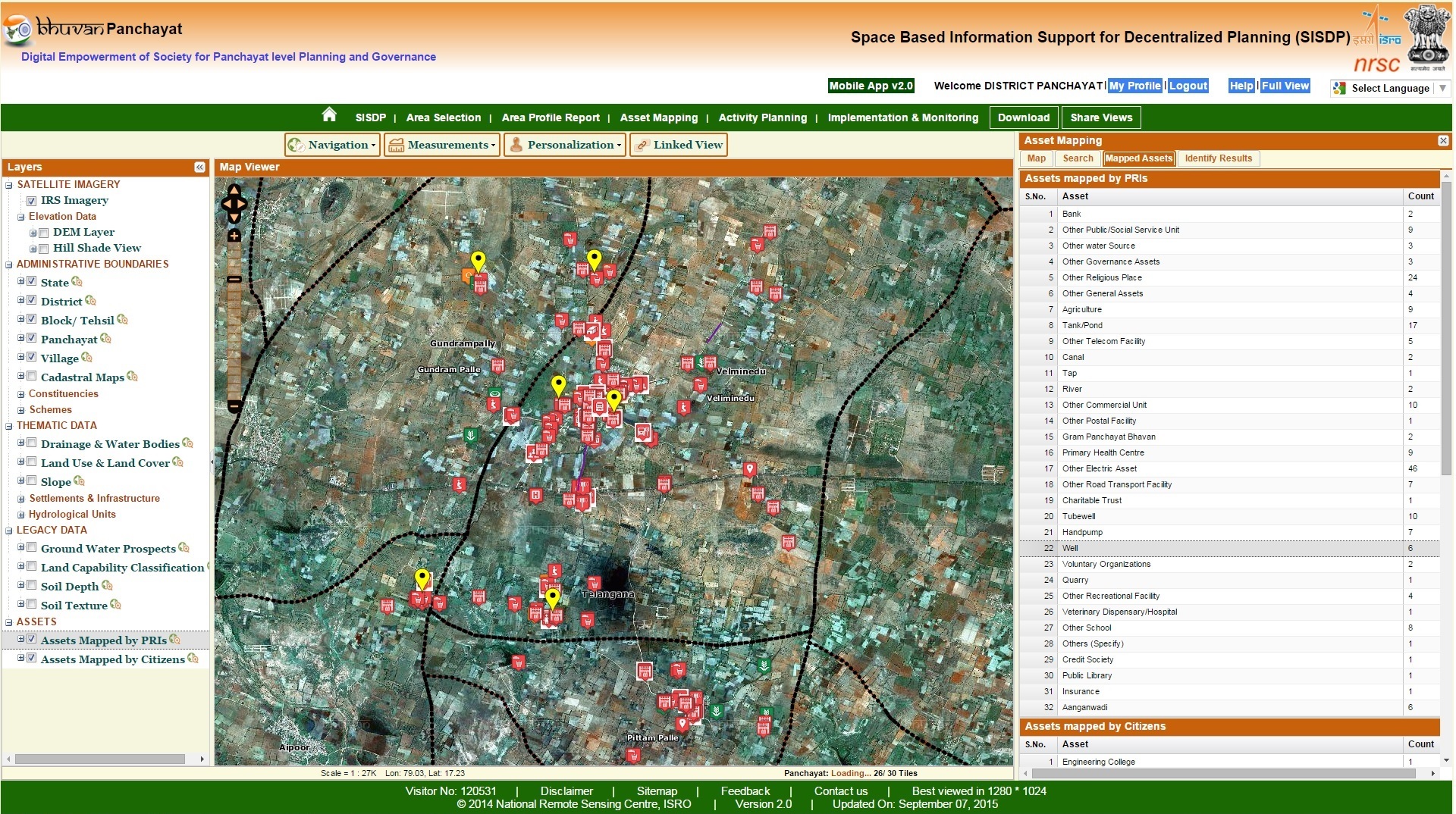
Rural Development depends on assessment of the required amenities and management of the existing ones, such as Roads,Schools,Hospitals and Sanitation etc, there is an urgent need of spatial inventory of the existing assets before investing for new assets as most of the database on assets doesn’t have spatial location. The objective of this project is asset mapping, activity planning, and implementation and monitoring of development activities at Gram panchayats level.
Bhuvan Panchayat Mobile App by NRSC/ISRO would be used in this project. This App is well integrated with web portal, it supports the services of mobile mapping and in web portal supports visualization and editing A pilot study was taken up by TRAC,in Veliminedu and Pittampally Grampanchayats of Chityal Mandal, a total of 244 assets were captured, which includes assets such as, Governance, Productive, Human resources, Natural resources and Civic Amenities. The spatial location, attribute information and photograph of each asset, is processed for Geodatabase, which is further used for spatial analysis to support the efficiency of asset management. It is understood that Asset Mapping helps in planning, transparency and making quick decisions to execute the projects at Grampanchayats level. As the work is appreciated at national level it is planned to extend the Asset mapping for Mahabubnagar district,later on entire State.